Why is London here at all? It’s thanks to the Romans
Most of us know that it was the Romans who founded London, (aka Londinium), but why, and why did they choose this spot? Well, the initial reasons were certainly convenience and strategic, but later this became economic and even later, arguably, retribution.
Let’s start with the first Roman ‘invasion’. That of Julius Ceasar in 55 and 54 BC. In fact, it is probably incorrect to label either of these as an “invasion”. Ceasar himself, describes his foray as retribution to punish the Celts, (a.k.a Britons), for supporting the Gauls against him.
In 55 BC he took two legions, (of between 7,000 and 10,000 men), plus a few cavalry and was, it is believed, repelled at the beachhead by Britons on foot and in Chariots. The level of resistance he received appeared to convince him he needed more support. So, after a “walk-around” Kent, he returned to Gaul. However, he returned the following year, 54 BC, with 5 legions of 25,000 men and some 2,000 cavalry. This time he marched inland and, finding the Thames as a barrier, he marched West along its banks reaching a ford close to present day Walton-on-Thames where he could cross.
Although there is an alternative theory that he used boats brought around the coast, from the beachhead, to cross downstream where Tilbury is today. Either way, his purpose was only the partial submission of the Britons, and thus to ensure he did not have an exposed flank in northern Gaul.
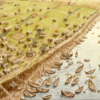
The real “invasion” took place in 43 AD under Claudius. That is to say under his instructions. The intention of this invasion was, I believe, two-fold. Not only to bolster the Emperor’s position by expanding the Empire, but also economic. In short, to control the source of two important raw materials. These were wool and, even more importantly, tin. Southern Briton had been known to be a rich source of tin for centuries before but had always been bartered for. If the Empire controlled the source of this vital metal, so much the better. Claudius sent one Aulus Plautius and four legions to subdue Briton and bring it into the Empire. Plautius did not follow Julius Ceasar’s tactics but sailed initially up the Medway. Then, finding the Thames “in the way” north, sailed up the Thames. The Thames was, as it is today, tidal, but at one point there were several islands across its path, which tended to reduce the ability of deep draft ships to go further. However, at this same point on both the North bank and the South bank was solid dry ground which was not reached at high tide. Thus, initially via a pontoon bridge, but shortly thereafter via a wooden structure, a bridge was created. Giving easy access across the river.
In a very short time, as one can imagine, this developed into a trading settlement, which was based on the northern bank. I am sure you can see where this is going. This was convenient for the Romans, as it enabled them to build some basic quays from which to offload supplies for their military in both the North and South at the same time.
This brings me to the Church of Saint Magnus-the-Martyr which is just the downstream side of the present London Bridge from Fishmongers Hall. Yes, I know it was built by Sir Christopher Wren in 1671 to 1687, after the Great Fire, (more on both in a later blog I expect), but it is key to us looking at the first London Bridge the Romans constructed. Not only is there a scale mode of the Medieval London Bridge within the church, but also, attached to the wall of Saint Magnus’ bell tower, is the remains of an oak pile, thought to be either from the Roman bridge or the nearby Roman wharf. It has been carbon dated and ring dates to the reign of Augustus Ceasar, so it was felled even before the Claudian invasion.
Close by, at the bottom Fish Street Hill at its junction with Lower Thames Street, almost opposite Saint Magnus, is where the Roman Bridge reached the North of the river. Even though this site is about 100 meters from the present river side, it is said that one would find the remains of the start of the bridge some meters below where one stands, as the Thames is thought to have been over a kilometre wide at this point during Roman occupation.
London was not initially the Capital of Roman Britain
So, how did London become the capital, and what, or who, was the moving force behind establishing London as the Capital of Roman Province of Britannia?
Enter that great British folk heroine, Queen Boudica of the Iceni. It is believed that initially the Iceni we allies of the Roman invaders. They appeared to live in cooperative harmony with the Romans under Aulus Plautius, and their main town of Camulodunum, (present day Colchester), became the first Roman ‘Capital’ of Britannia. However, later, in AD 60, when Boudica’s husband, King Prasutagus died, rather than honour his will, and the ancestral norm of the Celts, and let Boudica become ruler, the Roman rulers decided to annex the Iceni’s land. By then the Governor of Roman Britain was Gaius Suetonius Paulinus. He was away with a large part of his army, fighting in Wales when Boudica took up arms and led a revolt. So, there was a limited force to oppose her. She led her uprising initially against Camulodunum and sacked it. They then attacked and devastated Verulamium, (which was located where present-day St Albans stands) and finally to Londinium. The buildings in London, at that time, were mainly wood, with limited or no fortifications. It was, after all, mainly a trading town.
Once Paulinus had finally defeated Boudica, it was seen that London, with its very strategic position, which both allowed armies to march freely North or South and had a naturally defended southern flank, the Thames, was a more appropriate capital for the province.
So began the building of a ‘standard’ high status Roman City, with a Forum and Basilica, and defensive walls of earth and wood. At this time London was situated on two hills, what we now know as Ludgate Hill in the West and Tower Hill in the East, with a river, the Walbrook, almost dissecting the City.
To the East of the Walbrook stood the formal city structures, the Forum, Basilica, (parts of which are still visible under and within Leaden Hall market), and eventually the Governor’s residence. This residence, occupied by one Gneaus Julius Agicola, is thought to be approximately where Cannon Street Station stands today. To the West, initially, was primarily private accommodation and shops.
Whilst most of these properties, other than the Forum and Basilica, looked like they were stone built. In fact, they had mainly stone foundations with wattle and daub walls supported by wooden beams. Thus, the City did suffer devastating fires. The initial Roman Fort, housing about 600 soldiers, which was erected immediately post Boudica, was in the area of Fenchurch Street station, but after a particularly bad fire of circa 120 AD, it was decided to build a bigger fort to the Northwest of the City, and to rebuild or reinforce the walls surrounding the City in stone.
The remains of the fort built at this time can be seen on Noble Street, alongside the Plasterers Hall. It was significantly bigger than its predecessor and was built to a ‘standard Playing Card’ design. The same design as can be seen today at Vindolanda Fort up by Hadrian’s wall, although Vindolanda predates the Fort in London by about 45-50 years. Thus, it would have covered the buildings from London Wall in the North to Gresham Street in the South, and from just West of present-day Noble Street, almost as far East as Wood Street.
Shortly after the Fort was completed, the Governor instigated the building of the walls of the City. These were made to the standard Roman plan of large stone sections bounded and bonded by Roman concreate and red tile layers. In the case of London Wall, Kentish Ragstone was used as the main constituent of the Wall. The resulting structure was over 2 miles long and approximately 7½ yards, (circa 22 feet), high.
As well as the Fort in Noble Street, remains of the wall itself are still visible both in the East, with parts in the Tower of London, outside Tower Hill Station and north of the Station at 8-11 Cresent. Then all the way around, via the aptly named London Wall road, to the exposed part close to the Barber Surgeons’ Hall and then within the Barbican complex.
Having over 1,000 soldiers based at this ‘new’ fort and with the essential support personnel and families stationed there too, all now West of the Walbrook, this led to the inevitable need for entertainment. Hence, shortly after the fort and walls were completed, an Amphitheatre was built nearby. The outer range of this Amphitheatre has been marked on the courtyard of the Guildhall with a series of black flag stones in the otherwise light coloured flags. In addition, under the Guildhall Art Gallery, one can see the physical remains of this amazing structure.
Moreover, Roman Baths were built for public use, (the Governor’s palace is believed to have a set of private baths). Contrary to common belief however, these baths are not those baths known as Roman Baths off the Strand near Somerset House, which were more probably built in the 17th century. The only known remains of genuine Roman Bath are, I believe, those north of Lower Thames Street, just over 150m West of Bakers’ Hall. Thus, it was that, with hindsight, the late second century and early third century were the hay-days of Roman London.
By approximately 255 AD, the wharfs and quays were reduced, closed, or even replaced with defensive structures. The City was losing, one might say “had lost”, its primary commercial and trading basis, and had transitioned totally to a military and administrative role. This also led to the demise of the two main settlements for workers, traders and support individuals outside the Walls. One to the West, beyond Ludgate Hill and the other on the southern side of the bridge.
There are a number of theories as to why this took place. Firstly, this was a period of significant issues for the Roman Empire as a whole, with assassination of Emperors, uprisings and invasions and individual Generals declaring UDI from Roman, (such as one Marcus Cassianius Latinius Postumus, who did so for Gaul, Britain and most of Spain, declaring it the Gallic Empire). A second theory suggests that the Thames was becoming overly shallow due to silting, which, along with the ease of suppling troops in the north via other locations such as York, made the Thames no longer a valuable port of entry.
Whilst no one can be sure, I suspect it would have been, as usual, a mixture of both these events and others. All of which led to the steady decline in London as a Roman City. The end being in 410 AD when Roman rule finally collapsed with the departure of the troops from Britain. I have read of archaeological evidence which suggests that, by 450 AD, the City was largely deserted and in ruins. However, it has been also suggested that from this point small groups of mercenaries, including some very small-scale Germanic presence, used the City and remaining structures as dwellings or refuge.
However, it was not for at least another two hundred years before the Anglo-Saxons established a major settlement in the City.